Ride #10
A&P Excursion
Distance: 10.7 miles Elevation Gain: 767 feet
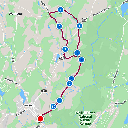
Ride Notes
A very Wantage Ride: hayfields, cornfields, barns, silos, rolling hills. An option for a 5-mile extension is suggested. Allow time to visit two old, rural cemeteries. The name of this ride is a misnomer; it’s so named because the Acme that stands now was an A & P for generations, and most locals and those of us who have been here awhile will always refer to it as the A & P. The ride is a “lollipop” loop—the first and last 3 miles are the same; the middle of the ride is a circular loop.
Directions
The ride starts at the Acme Supermarket parking lot on Rt 23, just south of Sussex.
0.0
Upon exiting the parking lot, turn left onto Lower Unionville Rd.
0.5
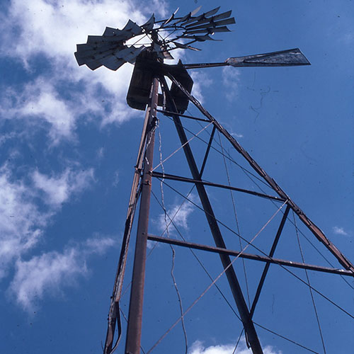
Windmill!
One of the very few remaining farm windmills in Wantage Township. Pausing for a moment here may encourage you to think about the incredible evolution of energy production.
0.75
Judge Beach Rd
A short side excursion (1.5 mi out and back) will take you onto a quiet, dead-end dirt road.
1.7
Hamming Lane
Unless you look, you wouldn’t know there is a good-sized farm at the end of this road.
2.1
August Lane
A very short zip through the cul-de-sac will give you a glimpse of Wantage suburbia.
2.9
Pass Possum Glen Rd on left.
3.7
Slauson Cemetery
Unfortunately, gravestones that were easy to read in the 1960s are now hard to decipher, thanks to acid rain. There are some here that are legible, and they make for some good investigating. Revolutionary War soldier Levi Ayers is buried here.
3.8
Merge right onto Rt 284.
4.0
Turn left onto Rose Morrow Rd.
Just ahead (before you turn) on your left is the former site of Uncle John’s Tavern, a place where you’d feel most welcome if you drove a pickup and wore farm overalls. A real working-man’s bar, from my recollection. Every time I pass here I wish I could go back, order a cold one, and bask in the past.
4.6
Welcome to Quarryville!
A station of the NY Midland Railroad was located here. The rail bed is the driveway of the industrial building on your left. The bed is visible on your right, especially after summer foliage has died.
A small quarry that mined bluestone was located about a mile from here and the stone was shipped from this station, about 70 miles from NYC. Try to imagine the store, creamery, and post office that stood near the railroad station. In 1936, immediately after the repeal of Prohibition, a distillery was located here. Apples from New Jersey and New York were processed into cider that was fermented into “High Point Apple Jack.” About 1.5 million gallons of cider was processed a year. The distillery burned in 1948.
4.9
Turn left to stay on Rose Morrow Rd.
5.4
Turn left onto Sally Harden Rd.
SIDETRIP: For a 5-mile around-the-block extension: At the intersection, turn right onto Sally Harden Rd. Turn left onto Beemer Rd. Turn left onto Rose Morrow. After passing barns, old farmhouses, silos, and farm fields, you’ll return to Ride Milepost 5.4. Continue from there.
6.6
Turn right onto Rt 284.
Don’t hesitate to stop at the Wantage Medical building. Visit the uber-friendly staff at Skylands Dental and set up that check-up you’ve been putting off.
7.0
Wantage Cemetery
The Wantage Methodist Episcopal Church was built across from the cemetery in 1831 and torn down in the 1950s. This cemetery has a few obelisks and some headstones with interesting symbolism. Whenever I see a hand with the finger pointing up on a headstone (there’s one here) I think of a few people I know that, on their demise, might have this symbol, but reversed!
7.1
Turn left onto Possum Glen Rd.
7.8
Turn right onto Lower Unionville Rd.
10.7
Return to Acme parking lot.