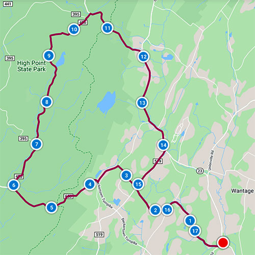
Ride #12
Kittatinny Up and Over
Distance: 17.7 miles Elevation Gain: 1768 feet
Ride Notes
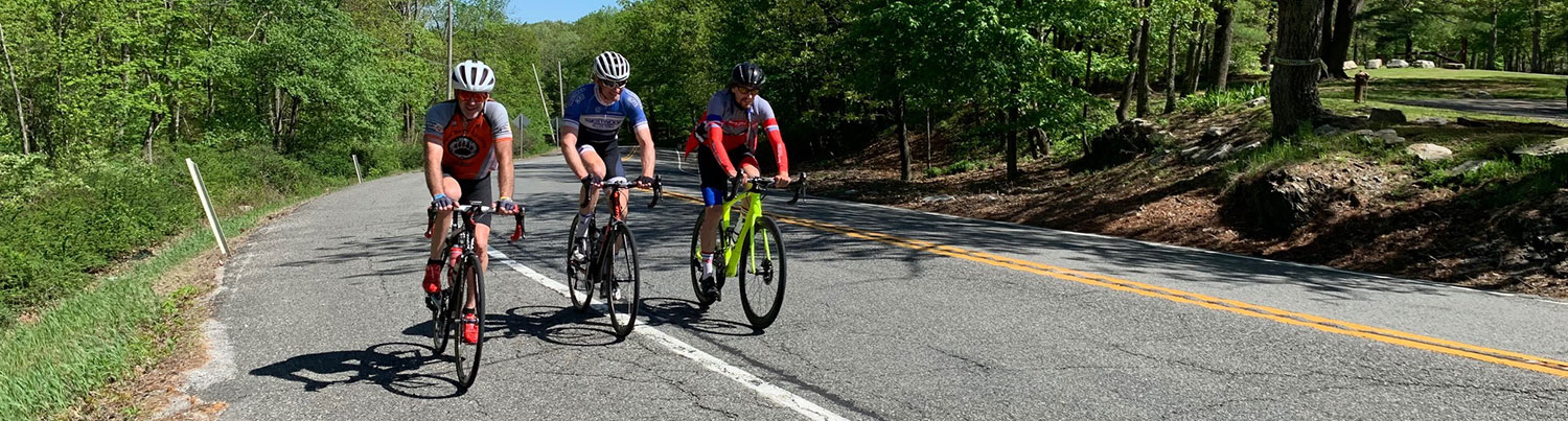
This ride is the longest and has the greatest elevation gain of all the rides. There is one section that should only be attempted by experienced riders—the mountain descent on Rt 23 past the Park Office. It’s steep, twisting, and has no shoulder at its steepest part. A safer alternative would be to make this a shorter, two-car ride. Park one car at the start and the other at the lot near the High Point Office.
You can extend this ride by 3+ miles if you follow directions for the High Point Monument Extension Ride.
Directions
The ride starts from the Wantage Township Municipal Building on Rt 23, approximately 2.5 miles north of Sussex.
0.0
From Wantage Twp Municipal Building, make a left onto Brown Rd.
0.1
Bear right to stay on Brown Rd.
1.5
Bear left onto Hickory Rd. at the road “triangle.”
1.8
Turn right onto Snover Rd.
2.7
Cross Rt 519.
3.2
Turn left onto Brink Rd.
For a one-mile extension to visit an old cemetery, turn right. In about a half mile, the Brink Cemetery will be on your left. It’s worth a visit, especially if you’re armed with Stories in Stone: a field guide to Cemetery Symbolism and Iconography, available at the Sussex County Library. Look for the stones with the clasped hands and the pointed fingers.
According to Sussex County Hauntings, by Wantage resident Eleanor Wagner, a supernatural event occurred on the road in front of the cemetery. I stopped here once and talked to a man and woman who were mowing the grass; they were relatives of deceased residents. They informed me of the apparition of a young woman dressed in white who frequents the back section of the graveyard.
Return and continue from milepost 3.2.
3.8
Turn right onto Deckertown Tpk.
Deckertown Turnpike was a stagecoach route from Jersey City to Milford, PA.
4.1
Milestone!
Look for the “milestone” painted red under the evergreen tree. The other Wantage milestone can be found in the Beemerville Loop Ride at mile 6.5.
4.5
HPSP Iris Trailhead on right. Enter Montague.
This 4.5 mile trail, paralleling and intersecting with the Appalachian Trail, extends to the park office on Rt 23. The hike affords a beautiful vista of Lake Rutherford, the reservoir for Sussex.
4.9
Appalachian Trail Parking Lot on right.
5.9
Turn right onto Sawmill Rd.
6.0
Red Barn Pond
A popular fishing spot
7.0
Pass Park Ridge Rd on your left.
7.2
Cross Tennessee Gas Pipeline
The meandering stream that parallels the road on your left is the Big Flatbrook, a stocked trout stream.
8.5
Pass Sawmill Lake Campsite Road on right.
8.7
Sawmill Lake
Fifty tent and small trailer sites are available spring till fall.
Sawmill Lake was the site of a natural cedar swamp that was dammed and used to power a sawmill. In the 1930s, the Civilian Conservation Corps dug the lake and built the stone dam that is in front of you. A series of photos depicting the lake’s and dam’s construction can be found in the book High Point State Park and the Civilian Conservation Corps. The book can be checked out of the Sussex County Library.
8.8
Pass exit of Sawmill Lake Campsite Rd.
9.0
Pass Ayers Trail on left.
9.4
Pass Mashipacong Trail.
10.3
Pass Park Ridge Rd on left.
10.4
Turn right onto Rt 23.
Use the wide shoulder.
10.9
HPSP Office
Stop for information, maps, water, bathroom, and just to look at the beautiful architecture of this building, built circa 1940.
(If you are adding the HPSP Monument Extension to your ride, carefully cross Rt 23, enter the main park and follow directions for Monument Extension Ride from milepost 0.5. Return and continue this ride from milepost 10.9.)
11.0
Pass HPSP Maintenance Yard on right.
11.1
Pass Appalachian Trail Parking Lot on right.
11.5
Gravel Carriageway to Lake Rutherford on right.
CHECK BRAKES! BE CAUTIOUS! CONCENTRATE!
This is a steep, twisting descent. At its steepest, you lose the shoulder.
11.8
Timplex Company on right.
11.9
Greenville Rd on left.
12.1
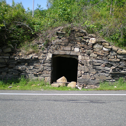
Stone Root Cellar on right.
Built by Jacob Slate in 1891
12.3
Fair Acres Farm on left.
The proprietor has converted a dairy barn as his office and showroom for decorative flower pots imported from Mexico. Stop for a visit.
12.6
Site of “Heater’s Tavern”
You can stop here for a beer, but only if you’re biking in the Twilight Zone, and that’s how I felt when I visited here back in the eighties—as if I had stepped right into one of Rod Sterling’s stories. Ask a local about Bill Heater for some colorful stories. His gravestone, in the Clove Cemetery, has a horse race track engraved on it. I was told he lay in his coffin with a racing stub and a cigar in his jacket pocket.
12.9
Pass Hankins Rd on right.
13.4
Colesville
The old Methodist Church on your right is now a residence.
13.6
Pass Colesville Fire Dept. on right and Mudtown Rd on left.
Wantage Township is served by volunteer fire and first-aid squads. A donation now gets paid forward to someone who will need help in an emergency. If you're a resident, consider volunteering.
In front of the house just past the firehouse, notice the large stone a few feet above the roadway. This would have served as a “step” for a wagon or coach, used so passengers wouldn’t have to step onto the dirt (or mud) road.
13.8
Elias Cole Restaurant
Stop for a bite (you’ve got about 3 miles left to ride) or come back after your ride. My son Glen’s recommendation: Taylor Ham & Cheese Sandwich. This suggestion comes with a caveat—it’s only on the breakfast menu, so unless you’re riding early, you’ll just have to return for breakfast another time.
14.1
Turn right onto Rt 519.
15.1
Turn left onto Snover Rd.
16.0
Turn left onto Hickory Rd.
16.3
Bear right. Hickory Rd turns to Brown Rd.
17.6
Turn left to stay on Brown Rd.
17.7
Return to Wantage Township Municipal Building.
Stop to look at our totem pole on the front lawn. This is a replica of the original 1920s totem pole that was located across the road and a little south of the Old Clove Church. That landmark was destroyed in a 2002 automobile crash. Our current pole was constructed by Wantage School students under the supervision of Mr. Allen Terwilliger and Mr. Robert Coates. A May 25, 2005 NJ Herald article about the pole can be viewed on microfilm at the S-W Library.
The Clove Cemetery across Rt 23 and the Old Clove Cemetery just south of the Municipal Building are also worth a visit.